


Wow, this could grow into something quite awesome. Pachube is –
a web service that enables people to tag and share real time sensor data from objects, devices and spaces around the world, facilitating interaction between remote environments, both physical and virtual. The idea is to make it relatively simple to “plug” together interactive projects and buildings around the world, as well as to create embeddable graphs of sensor feeds.
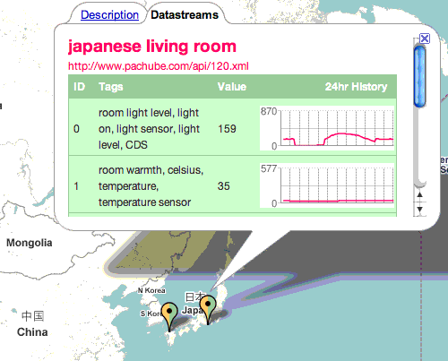
Only eighteen feeds conected at the time of this post – but the datastreams are already quite interesting – from a Japanese living room to a swing in Sweden. Head over to the site to learn how to connect your own sensor/stream – Pachube Thanks, Chuckster!
Update: Interested Londoners can learn more about Pachube –
Extended Environments/Arduino/Networked sensors workshop
Using Arduino and Pachube, Usman will lead a 2-day workshop, June 21 & 22, at Arup’s headquarters in London, kindly hosted by Tinker.it! The Extended Environments workshop will form a basic introduction to networked sensors, making particular use of Extended Environments Markup Language (EEML) and Pachube. Please join us if you would like to learn more about using Arduino to connect together remote environments across a network, share sensor data, or create interactive environments using Pachube, but you will need to register by June 15th!
– [ Only 3 days left to sign up! ] more info @ Tinker.it
10 thoughts on “Realtime sensor network awaits your input … or output”
Comments are closed.
ADVERTISEMENT
Join Make: Community Today


Tinker is holding a workshop on using Arduino with Pachube next week in London (june 21 and 22): http://tinker.it/now/2008/06/08/extended-environments-workshop/
I have been thinking something simular but with a software/platform/API called EPICS
it’s started as a fast realtime control system for particle accelerators but they opensourced it.
it’s quite easy to use and they offer free video lectures and have an active email form.
it makes it easy to develop a sensor/output network. and access the information via a easy to develop client.
http://www.aps.anl.gov/epics/index.php
there is already alot of supported hardware, and it’s easy to add your own.
I have been thinking about writing software for the FTDI 245, USB chip cause it has 8 I/O pins ready to go. and would be easy(and cheap) to interface to pretty much anything.
I have seen epics in action and it’s sexy.
Hams have a system called APRS do that allows for remote sensing and command.
Nodes can pass traffic for other nodes in a zigbee-esque manner as well as pass along the data to internet gateways.
It’s similar project I work on. The idea is to get data from various sensors and redistribute it using open protocols and standards.
Project link here: http://www.steliosm.net/sdss.html
I’m surprised that I haven’t seen SensorML brought up. The authors of EEML don’t even mention it. Seems a shame to re-invent at least a part of the wheel when a prominent geospatial standards body has an XML specification for sensor descriptions. If EEML brings something new to the table (XML container for discreet pieces of data and abstract geography?), it would be nice to see it incorporated.